Introduction and Explanation of Plant Trail Guides
Introduction
Highlights of This Trail
Fieldwork Dates and Summary of List Changes With Time
Botanical Trip Reports
The Plant Guide
Comments On Specific Species
Introduction
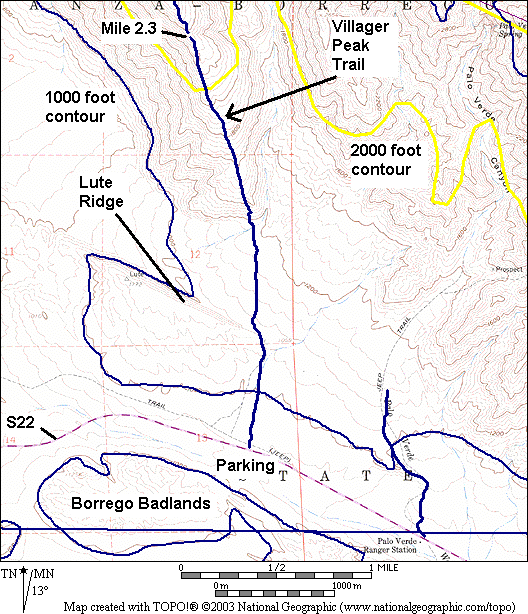
The Villager Peak Trail climbs a north-south ridgeline of the Santa Rosa Mountains that is directly north of the Borrego Badlands and directly east of Clark Dry Lake. Even the lowermost portion of that ridgeline gives excellent views of the Borrego Valley and surrounding mountains, especially of the Borrego Badlands, with distant views into Mexico.
This is an unsigned use trail. The trail begins at milepost 31.8 on Highway S22 at its junction with the Truckhaven Trail, at Call Box S22-319, and one simply heads north toward the easternmost tip of Lute Ridge. The first 0.64 miles are in a wash, and I found two different paths with a number of footprints; both are shown in the map below. This makes it difficult to create a single plant trail guide, so you may have to look on the other path for a listed species.
Once at the east end of Lute Ridge, the trail becomes very clearly defined and well marked with cairns. From that point on, there should be no ambiguity in following the plant trail guide.
The trail stays in the flattish dissected alluvial plane, with a net gain of only 215 feet of elevation, until mile 1.3, where the fun begins elevation-wise. The trail leaves the wash and ascends a steep cliff on a well-marked, switchbacked trail to get on the north-south ridgeline. Once on the ridgeline, the views open up, and the trail beckons one further to see what each step forward on the ridgeline will reveal.
The trail is described in Schad, Afoot and Afield in San Diego County. Schad says that Villager and Rabbit Peaks are among the most popular destinations for peak-baggers in the Anza-Borrego Desert. The round trip to Villager Peak is 13 miles, with 5000 feet of elevation gain and loss.
We have surveyed only to mile 2.8, making a round trip of 5.6 miles with 1950 feet of elevation gain and loss. That portion of the trail is shown in the map below.
See also:
- The Anza-Borrego Desert Natural History Association's Lute Fault Scarp
- Bill Sullivan's Villager Peak Walk
- Bob Burd's Villager Peak / Rabbit Peak
- hpshiker's 22 February 2003 photos
- cluggish's 18 April 2005 photos.
Highlights of This Trail
The following histogram gives the number of trails in our database that contain each taxon on this trail. I had 227 trails and surveyed areas in my database when this histogram was made; 71 of those trails, including this one, are in Anza-Borrego State Park. A number of "1" means the taxon has only been found only on this list, among all the trails in our database.
| Number of Trails Containing A Taxon | Number Of Taxa On This Trail | % of Taxa On This Trail |
|---|---|---|
| 1 | 0 | 0% |
| 2 | 3 | 3% |
| 3 | 0 | 0% |
| 4 | 2 | 2% |
| 5 | 1 | 1% |
| 1-5 | 6 | 6% |
| 6-10 | 6 | 6% |
| 11-15 | 8 | 8% |
| 16-20 | 8 | 8% |
| 21-25 | 11 | 12% |
| 26-30 | 7 | 7% |
| 31-35 | 8 | 8% |
| 36-40 | 7 | 7% |
| 41-45 | 8 | 8% |
| 46-50 | 3 | 3% |
| 51-55 | 3 | 3% |
| 56-60 | 5 | 5% |
| 60-65 | 4 | 4% |
| 66-70 | 5 | 5% |
| 71-75 | 4 | 4% |
| 76-80 | 2 | 2% |
| Total Taxa | 95 | 100% |
Five additional taxa are not in the above table, since they are found only off-trail.
The three species that are found on only a single other trail or survey are: Linanthus jonesii, Cryptantha barbigera var. fergusoniae, and Prenanthella exigua. However, Cryptantha barbigera var. fergusoniae occurs on additional trails, which have not yet been updated to distinguish this variety, which was not present in the 1996 First Edition Jepson Manual.
Fieldwork Dates and Summary of List Changes With Time
The following table gives the dates the trail was walked and taxa recorded. After each visit, the table gives the total number of taxa on the list and the breakdown of the taxa without positive identification. See Explanation of Plant Trail Guides to understand the symbols below.
| Visit Date | Visit # | # taxa | # "?" | # "sp" | # "~" | # "ssp" |
|---|---|---|---|---|---|---|
| 1/29/2008 | 1 | 54 | 1 | 7 | 9 | 1 |
| 3/25/2008 | 2 | 77 | 0 | 0 | 1 | 1 |
| 12/17/2010 | 3 | 84 | 0 | 0 | 1 | 1 |
| 2/8/2011 | 4 | 95 | 0 | 0 | 0 | 1 |
The trail was covered to mile 2.34 on 1/29/08, and to mile 2.76 on 2/8/11.
Botanical Trip Reports
The Plant Guide
The mileages have been obtained from a GPS recording for the species, which did not capture the switchbacks in the trail. Furthermore, the trail is ill-defined for the first 0.64 miles, so your route may not match the route we took. The relative mileages are probably accurate to ~0.02 miles, with the absolute accuracy somewhat worse.
Because we didn't think this trail was going to be well enough defined to create a plant trail guide on the first survey trip, we didn't record which side of the trail the species were found. Some sides were supplied from memory; others were obtained on later trips. But due to the braided nature of the trail, you should not trust the side religiously.
Because of the ill-defined trail, the # plants in the following does not follow the convention of the other plant trail guides. Instead, it is the number of plants in a much-larger area around the trail.
Version for printing, without lines and other text on this page: html (4 pages) or pdf Clickbook booklet (1 double-sided page). (See printing instructions for an explanation of these options)
See Explanation of Plant Trail Guides for an explanation of the column headers (except see the note immediately above about the # plants in the # here column).
| mile | s | # | id | Common Name | Latin Name | #here | #all |
|---|---|---|---|---|---|---|---|
| 0.00 | Begin guide at Call Box S22-319 at jct. of S22 and Truckhaven Trail; head north toward easternmost tip of Lute Ridge on either one of two use trails; elevation ~965 feet (294 m). The following 8 annuals are all at the trailhead vicinity, given in alphabetical order | ||||||
| 0.00 | b | 1 | hairy sand-verbena | Abronia villosa var. villosa | 20 / 4 | 21 | |
| 0.00 | b | 2 | frost mat | Achyronychia cooperi | 10 / 3 | 13 | |
| 0.00 | b | 3 | *Asian mustard | Brassica tournefortii | 99 / 9 | 65 | |
| 0.00 | b | 4 | desert pincushion | Chaenactis stevioides | 10 / 1 | 17 | |
| 0.00 | b | 5 | narrow-leaved cryptantha | Cryptantha angustifolia | 99 / 9 | 37 | |
| 0.00 | b | 6 | downy dalea | Dalea mollissima | 3 / 2 | 14 | |
| 0.00 | b | 7 | desert plantain | Plantago ovata | 99 / 9 | 51 | |
| 0.00 | b | 8 | *Mediterranean schismus | Schismus barbatus | 99 / 9 | 70 | |
| 0.00 | b | 9 | creosote bush | Larrea tridentata | 99 / 9 | 78 | |
| 0.00 | b | 10 | burroweed | Ambrosia dumosa | 99 / 9 | 71 | |
| 0.00 | 11 | Emory's indigo-bush | Psorothamnus emoryi | 2 / 1 | 30 | ||
| 0.02 | r | 12 | white rhatany | Krameria grayi | 50 / 9 | 56 | |
| 0.03 | r | 13 | brown-eyed primrose | Camissonia claviformis ssp. peirsonii | 99 / 9 | 42 | |
| 0.04 | 14 | desert lily | Hesperocallis undulata | 10 / 3 | 22 | ||
| 0.04 | 15 | California suncup | Camissonia californica | 99 / 9 | 80 | ||
| 0.04 | r | (pencil cholla, Opuntia ramosissima) | |||||
| 0.06 | 16 | big galleta | Pleuraphis rigida | 40 / 9 | 62 | ||
| 0.07 | r | 17 | Arizona lupine | Lupinus arizonicus | 30 / 9 | 38 | |
| 0.08 | l | 18 | desert chicory | Rafinesquia neomexicana | 10 / 3 | 45 | |
| 0.08 | l | 19 | heliotrope phacelia | Phacelia crenulata var. ambigua | 99 / 9 | 21 | |
| 0.08 | 20 | silver cholla | Opuntia echinocarpa | 99 / 9 | 33 | ||
| 0.10 | b | 21 | ocotillo | Fouquieria splendens ssp. splendens | 99 / 9 | 69 | |
| 0.15 | r | 22 | hairy-podded pepper-grass | Lepidium lasiocarpum var. lasiocarpum | 50 / 5 | 49 | |
| 0.15 | r | 23 | desert dandelion | Malacothrix glabrata | 10 / 2 | 33 | |
| 0.15 | 24 | button encelia | Encelia frutescens | 20 / 5 | 15 | ||
| 0.15 | 25 | spectacle-pod | Dithyrea californica | 5 / 1 | 13 | ||
| 0.16 | 26 | Parish's poppy | Eschscholzia parishii | 20 / 9 | 29 | ||
| 0.16 | l | 27 | small-flowered poppy | Eschscholzia minutiflora ssp. minutiflora | 50 / 9 | 30 | |
| 0.16 | l | 28 | white tackstem | Calycoseris wrightii | 50 / 9 | 11 | |
| 0.18 | l | 29 | pencil cholla | Opuntia ramosissima | 30 / 9 | 23 | |
| 0.18 | r | 30 | California barrel cactus | Ferocactus cylindraceus+ | 99 / 9 | 54 | |
| 0.19 | l | 31 | sweetbush | Bebbia juncea var. aspera | 30 / 7 | 75 | |
| 0.25 | 32 | bearded cryptantha | Cryptantha barbigera | 50 / 9 | 33 | ||
| 0.26 | l | 33 | rush milkweed | Asclepias subulata | 8 / 2 | 10 | |
| 0.26 | 34 | wire-lettuce | Stephanomeria pauciflora var. pauciflora | 30 / 5 | 70 | ||
| 0.26 | 35 | Thurber's sandpaper-plant | Petalonyx thurberi ssp. thurberi | 30 / 3 | 29 | ||
| 0.27 | l | 36 | desert lavender | Hyptis emoryi | 30 / 5 | 62 | |
| 0.27 | l | 37 | wishbone plant | Mirabilis bigelovii var. retrorsa | 20 / 5 | 49 | |
| 0.27 | l | 38 | cheesebush | Hymenoclea salsola var. salsola | 99 / 5 | 58 | |
| 0.27 | l | 39 | desert needle | Palafoxia arida var. arida | 2 / 1 | 39 | |
| 0.29 | 40 | indigo bush | Psorothamnus schottii | 50 / 7 | 59 | ||
| 0.31 | r | 41 | Palmer's coldenia | Tiquilia palmeri | 10 / 3 | 22 | |
| 0.32 | r | 42 | Booth's desert primrose | Camissonia boothii ssp. condensata | 50 / 7 | 38 | |
| 0.33 | l | 43 | Thomas' buckwheat | Eriogonum thomasii | 20 / 9 | 33 | |
| 0.37 | l | 44 | hairy desert-sunflower | Geraea canescens | 1 / 1 | 18 | |
| 0.38 | r | 45 | desert trumpet | Eriogonum inflatum | 30 / 3 | 57 | |
| 0.38 | b | 46 | small-seeded spurge | Chamaesyce polycarpa | 50 / 3 | 71 | |
| 0.40 | 47 | rock hibiscus | Hibiscus denudatus | 50 / 9 | 39 | ||
| 0.40 | 48 | Texas filaree | Erodium texanum | 5 / 2 | 16 | ||
| 0.40 | 49 | Guadalupe cryptantha | Cryptantha maritima | 99 / 9 | 33 | ||
| 0.40 | 50 | broad-fruited combseed | Pectocarya platycarpa | 2 / 2 | 6 | ||
| 0.42 | 51 | brittle spineflower | Chorizanthe brevicornu var. brevicornu | 99 / 9 | 45 | ||
| 0.48 | r | (catclaw, Acacia greggii; brittlebush, Encelia farinosa) | |||||
| 0.49 | l | 52 | white-stemmed blazing star | Mentzelia albicaulis | 1 / 1 | 8 | |
| 0.58 | 53 | brittlebush | Encelia farinosa | 99 / 9 | 74 | ||
| 0.59 | 54 | dune primrose | Oenothera deltoides ssp. deltoides | 20 / 3 | 9 | ||
| 0.59 | 55 | Schott's calico | Loeseliastrum schottii | 5 / 2 | 18 | ||
| 0.60 | Jct. Lute Ridge to west; trail is now well defined, well marked with cairns; elevation 1040 feet (317 m) | ||||||
| 0.62 | Cross small drainage | ||||||
| 0.63 | 56 | pebble pincushion | Chaenactis carphoclinia var. carphoclinia | 99 / 9 | 23 | ||
| 0.63 | 57 | six-weeks three-awn | Aristida adscensionis | 99 / 9 | 28 | ||
| 0.63 | 58 | trailing four o'clock | Allionia incarnata | 10 / 3 | 21 | ||
| 0.81 | l | 59 | beavertail cactus | Opuntia basilaris var. basilaris | 30 / 9 | 63 | |
| 0.81 | l | 60 | yellow-head | Trichoptilium incisum | 10 / 3 | 18 | |
| 0.87 | l | 61 | star gilia | Gilia stellata | 10 / 5 | 18 | |
| 0.89 | r | 62 | ~ | fivewing spiderling | Boerhavia intermedia | 30 / 1 | 12 |
| 0.89 | r | 63 | bracted blazing star | Mentzelia involucrata | 5 / 2 | 30 | |
| 0.92 | l | (Pima rhatany, Krameria erecta) | |||||
| 0.92 | l | 64 | cottontop cactus | Echinocactus polycephalus var. polycephalus | 1 / 1 | 4 | |
| 0.95 | r | 65 | devil's spineflower | Chorizanthe rigida | 10 / 2 | 24 | |
| 0.95 | l | 66 | desert star | Monoptilon bellioides | 20 / 3 | 19 | |
| 1.00 | b | 67 | bristly langloisia | Langloisia setosissima ssp. setosissima | 5 / 2 | 8 | |
| 1.00 | l | 68 | Gander's cholla | Opuntia ganderi+ | 99 / 9 | 57 | |
| 1.03 | l | (fish-hook cactus, Mammillaria tetrancistra) | |||||
| 1.05 | r | 69 | Emory's rock-daisy | Perityle emoryi | 99 / 9 | 45 | |
| 1.07 | l | 70 | catclaw | Acacia greggii | 5 / 1 | 69 | |
| 1.07 | r | (threadstem, Pterostegia drymarioides; glandular nemacladus, Nemacladus glanduliferus var. glanduliferus; desert mistletoe, Phoradendron californicum; Mojave ragwort, Senecio mohavensis) | |||||
| 1.08 | r | 71 | narrowleaf ditaxis | Ditaxis lanceolata | 99 / 3 | 47 | |
| 1.08 | l | 72 | desert five-spot | Eremalche rotundifolia | 5 / 1 | 15 | |
| 1.08 | l | 73 | ssp | curvenut combseed | Pectocarya recurvata | 50 / 2 | 21 |
| 1.08 | l | 74 | purple three-awn | Aristida purpurea | 30 / 9 | 21 | |
| 1.10 | r | 75 | whispering bells | Emmenanthe penduliflora var. penduliflora | 5 / 3 | 37 | |
| 1.13 | l | 76 | California fagonia | Fagonia laevis | 50 / 3 | 32 | |
| 1.14 | r | 77 | Nevada cryptantha | Cryptantha nevadensis | 2 / 2 | 5 | |
| 1.16 | r | (pygmy-weed, Crassula connata; woolly lipfern, Cheilanthes parryi) | |||||
| 1.17 | r | 78 | California filago | Filago californica | 50 / 1 | 39 | |
| 1.17 | r | (desert agave, Agave deserti) | |||||
| 1.18 | r | 79 | Mojave ragwort | Senecio mohavensis | 50 / 1 | 28 | |
| 1.20 | r | 80 | woolly lipfern | Cheilanthes parryi | 10 / 1 | 41 | |
| 1.21 | l | 81 | smoke tree | Psorothamnus spinosus | 10 / 1 | 33 | |
| 1.23 | r | (ghost flower, Mohavea confertiflora; pygmy-cedar, Peucephyllum schottii; Yuma spurge, Chamaesyce setiloba; strigose lotus, Lotus strigosus) | |||||
| 1.23 | l | (blue palo verde, Cercidium floridum ssp. floridum) | |||||
| 1.23 | r | 82 | Jones' linanthus | Linanthus jonesii | 7 / 1 | 2 | |
| 1.23 | r | 83 | Santa Rosa Mountain bearded cryptantha | Cryptantha barbigera var. fergusoniae | 2 / 1 | 2 | |
| 1.23 | Leave wash and ascend steep cliff on well-marked, switchbacked trail to get on ridge; elevation ~1180 feet (360 m) | ||||||
| 1.27 | l | 84 | thick-leaved ground cherry | Physalis crassifolia | 1 / 1 | 35 | |
| 1.37 | 85 | teddy-bear cholla | Opuntia bigelovii | 99 / 9 | 43 | ||
| 1.76 | 86 | Pima rhatany | Krameria erecta | 50 / 9 | 25 | ||
| 1.77 | l | (California trixis, Trixis californica var. californica) | |||||
| 1.80 | l | (San Felipe dogweed, Adenophyllum porophylloides) | |||||
| 1.82 | r | 87 | beetle spurge | Euphorbia eriantha | 1 / 1 | 12 | |
| 1.88 | 88 | desert agave | Agave deserti | 99 / 4 | 43 | ||
| 2.01 | r | 89 | fish-hook cactus | Mammillaria tetrancistra | 2 / 1 | 9 | |
| 2.20 | elevation 2260 feet (690 m) | ||||||
| 2.20 | The following species are from a separate survey of the area above this point, and hence are not necessarily on trail: | ||||||
| 2.20 | 90 | California trixis | Trixis californica var. californica | 5 / 3 | 41 | ||
| 2.28 | l | 91 | strigose lotus | Lotus strigosus | 2 / 1 | 68 | |
| 2.31 | 92 | goldenhead | Acamptopappus sphaerocephalus var. sphaerocephalus | 2 / 1 | 4 | ||
| 2.40 | O. ganderi with pink spines | ||||||
| 2.51 | 93 | bajada lupine | Lupinus concinnus | 1 / 1 | 52 | ||
| 2.76 | b | 94 | bright-white | Prenanthella exigua | 20 / 1 | 2 | |
| 2.81 | 95 | California matchweed | Gutierrezia californica | 1 / 1 | 19 | ||
| 2.91 | First view of Rattlesnake Spring to right; elevation 2900 feet (884 m) | ||||||
| 3.50 | Elevation 3280 feet (1000 m); knob 3261 feet to right | ||||||
| 4.50 | Flattish area at elevation ~4300 feet (1310 m) | ||||||
| 6.00 | First area of green trees marked on topo map; elevation ~5300 feet (1615 m) | ||||||
| 6.30 | Peak just before Villager Peak; elevation 5640 feet (1719 m) | ||||||
| 6.60 | Villager Peak; elevation 5756 feet (1754 m) | ||||||
Comments On Specific Species
Ferocactus cylindraceus. The varieties are not recognized in the Flora of North America treatment.
Opuntia ganderi. The population on this trail has spines that range from the normal white / yellow to a beautiful pink color which we've never seen elsewhere in the Borrego Desert. Jon Rebman has seen this variation in one other place, along old Hwy 80 from the Jacumba exit to the InKoPah exit in San Diego County. He and Mike Mayer found that the DNA of those plants had no significant differences from the DNA of plants with the normal spine color.
Jon recognizes another variety of O. ganderi that is endemic to Baja CA which has three very distinctive spine color forms (pink, yellow, and white). Jon says that these spine color forms frequently occur together, producing very attractive displays.